
Los Osos CSD 2024-2025 Water Report
The purpose of this report is to provide the community with an overview of the District’s water supply and water supply outlook, water production history, rainfall totals, per capita water use trends, and other pertinent water related information. A report, similar to this one, will be provided to the Board annually at the June Board meeting.
Water Supply
The District’s single source of water supply is from the Los Osos Groundwater Basin which is adjudicated and managed by a coordinated effort with the District, Golden State Water Company, S&T Mutual Water Company and the County of San Luis Obispo. These entities make up the Basin Management Committee which oversees the implementation of the groundwater management plan known as the Basin Plan. Implementation of the programs (mainly Programs A & C) in the Basin Plan fall mainly on the water purveyors with BMC assistance and support for data collection and the commissioning of additional studies when needed. Implementation of the Basin Plan, planning for a water resilient water supply future and maintaining existing infrastructure are the key challenges facing the District.
The following are updates on the District’s water supply and projects:
Rehabilitation of Existing Wells- Since 2019, the District has had to rehabilitate (rebuild) three of its four existing lower aquifer wells and one upper aquifer well. This is an indication of the age of the well infrastructure and the fragile nature of the water supply system. When a well is out of service, it puts stress on the remaining wells to make up the difference. This is especially problematic when the District is trying to cut production at the Palisades and 8th Street wells to combat seawater intrusion.
Program A- Program A entails shifting and/or adding water production from the upper aquifer (Zone C). To implement this program, the District has an upper aquifer well at the South Bay site which requires nitrate removal equipment. The decision was made this past year to take the well out of service. The decision was based on the positive test for PFAS at a relatively high level and the failure of the Nitrate analyzer. The cost for PFAS treatment and the high cost of replacing the analyzer prompted the decision. This was a low producing well in terms of gallons per minute that can be pumped, and it is expensive to maintain.
The District does have another upper aquifer well at the 8th Street water yard location. This well has added extra capacity to the water system and works well in coordination with the lower aquifer well at the same location.
Program C- the strategy outlined in Program C is to shift pumping from the western portion of the basin in Zones D and E to the middle and east portions. The District has been working on the Program C well project for over five years. The completion date has been delayed caused by scheduling issues with PG&E. It should be up and operational in July 2025. This will add operational integrity to the District’s well infrastructure and add safe yield to the basin sustainable yield estimates.
Water Supply Resiliency Intertie Project- The District has been working on the Water Supply Resiliency project since October 2022. This project will add a connection to the regional water supply network by connecting to the State Water pipeline in the Chorro Valley. The strategy is to bring imported water during wet years to offset pumping in the groundwater basin. This would allow for better recharge rates during average or above average rainfall years. During periods of drought, the basin will be better equipped to sustain the community’s water needs. Preliminary engineering design and environmental impact assessment work has been completed.
Next steps would be to find project financing to complete the design and initiate construction of the pipeline. Congressman Carbajal was successful in having the project part of the 2025 Water Resource Development Act bill that was approved in December 2024 by Congress. It is now up to the Army Corp of Engineers (Corp) to put the project in their workplan for 2025. The District is still waiting on the Corp for their decision.
The District still needs to negotiate with the County for an allocation from the State Water Project. Progress is being made by the County on adopting a new State Water Policy which will assist both the County and the District in negotiating.
Water Production
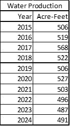
One of the key goals in the Basin Plan is decrease production not only from wells on the westerly side of the groundwater basin but to also track water use by customers in an effort to lower overall water production. Tracking production provides the District with valuable information on customer water consumption, monitoring the water systems’ water loss and tracking revenues to support the operations of the water system. The following is the District’s water production numbers since 2015 as reported in the BMC’s annual monitoring report:

As indicated in the table and chart, overall, water production has steadily decreased over this period of time, even during drought and above rainfall periods. Since around 2019, water production has been relatively stable in the District’s service area.
Rainfall
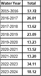
Since the District’s water supply is dependent on groundwater recharge from rainfall, tracking the cumulative impacts of rainfall amounts on water levels in the aquifer is one of several key factors on determining the sustainability of the basin. The District’s rainfall year is from July through June. The District’s Water Shortage Contingency Plan (WSCP) refences the date of March 31st of each year as the point in time when the determination of if the District should increase or decrease the water shortage stage based on the trigger mechanism defined in the WSCP. The following table and chart provide rainfall total since 2015.

Residential Per Capita Water Use
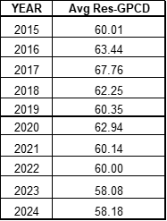
Residential per capita water use is defined as the amount of water used per person per day in a household. This includes both indoor and outdoor water consumption. It is calculated by using a California developed formula that uses total monthly production, the percentage of both single and multi-family residential accounts versus all accounts, population and number of days in the particular month to calculate the per capita number. Per capita water use does fluctuate from month to month and year to year mostly driven by climatic conditions, i.e. rainfall, drought conditions, etc. The following table and chart provide the annual average residential per capita water for each year going back to 2015.

As indicated, residential per capita water use has remained fairly constant for a number of years.
Water Shortage Contingency Plan - Water Conservation Stage
The WSCP was updated in October 2023. The update included modifications to the climatic triggers to enter and exit the various stages based on current conditions and operational experience. The District moved to a Stage II of the WSCP since there was above average rainfall in both 2022-23 and 2023-24.
Given the amount of rainfall received to date during 2024-25 which is indicating below average rainfall and the slight decrease in the Basin Management Committee’s Water Level Metric in 2024, the staff is recommending staying at Stage II.